DAO HyperAI LAB'S OVERALL RESEARCH PROGRAM
|
|
|
RESEARCH HIGHLIGHTS |
|
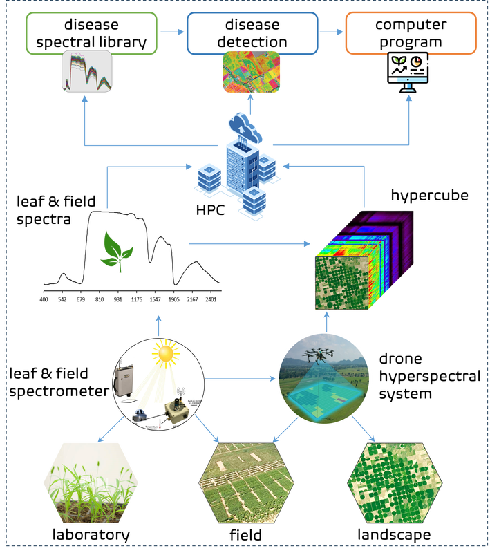
Multi-scale spectral database and deep learning for crop disease monitoring
|
In recent years, several fungal, viral and bacterial pathogens that were sporadic or unknown have been reported in various crops across the US and the state of Colorado, resulting in significant yield losses. The integration of drone hyperspectral imaging and deep learning (DL) provides precise and real-time detection and monitoring of disease spread, reducing diagnostic cost, and increasing throughput compared to laboratory methods. We aim to develop a crop disease spectral database and a disease detection computer program to facilitate practical and commercialized disease management in Colorado crops by incorporating drones hyperspectral imaging and DL. Specific objectives include 1) build the first multi-scale spectral database for common crop diseases in Colorado; 2) build a Python disease detection computer program to facilitate the implementation of drone-based disease monitoring; 3) create a guidebook to guide the design and implementation of the technology; and 4) improve student training in digital agriculture at Colorado State University and in the state. We expect this project will accelerate the development of data-driven scientific discovery and commercial applications for a wider and more efficient use of drone and AI technologies in modern digital farming.
--- Collaborators: Roberts Lab, CSU-Agricultural Biology |
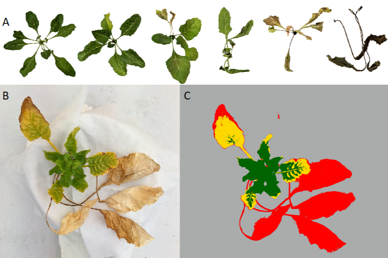
Disease-resistant Sugar Beet breeding with close-range and drone hyperspectral imaging
|
In this study, we integrate machine learning with multi-scale hyperspectral imaging to quantify foliar chemistry, rate disease severity, and characterize disease resistance mechanism for breeding of disease-resistant sugar beet. The project objectives include 1) developing a multiscale spectral library and a computer program for disease severity rating; 2) determining spectral bands, regions, and spectral indices that are distinct between healthy and disease-infected plants and generate a trait database for sugar beet breeding; and 3) characterizing how plants of different genes resist diseases at farm scale. The experiments are conducted at both greenhouse (using a close-range hyperspectral imaging system) and farm (using drone hyperspectral and multispectral imaging systems) levels to evaluate the scalability of the approach.
--- Collaborators: USDA-ARS in Fort Collins, Colorado |
Plant-insect herbivore interactions and plant chemical defense in Aspen forest
|
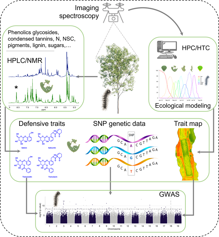
Imaging spectroscopy allows accurate quantification of plant defensive compounds, providing essential information for predicting the spread and impact of herbivores on host species, as well as on plant tradeoffs between allocation of resources to growth and defense. There is still much we do not know about the genetic underpinning of variation in defense traits. We investigate the impact of Lymantria dispar on variation in defensive traits and other chemistries associated with a defoliation across 519 aspen genotypes at the WisAsp common garden to understand potential genetic underpinnings of differential chemical responses. We integrate field and lab measurements with imaging spectroscopy (airborne HySpex sensor), LiDAR, and biological modeling (BioSIM model). This study aims to 1) quantify and assess genetically-driven chemical variation using imaging spectroscopy, 2) assess mechanism of plant resource allocation to defense and growth, 3) identify genes and genomic regions associated with chemical responses. This study sets a methodological basis for the remote assessment of chemical defense against insect infestation in forest and agricultural research at various spatial and temporal scales.
--- Collaborators: UW-Madison, University of Minnesota, Purdue University, NASA-JPL |
Plant-insect interactions - Machine learning for insect feeding behaviours
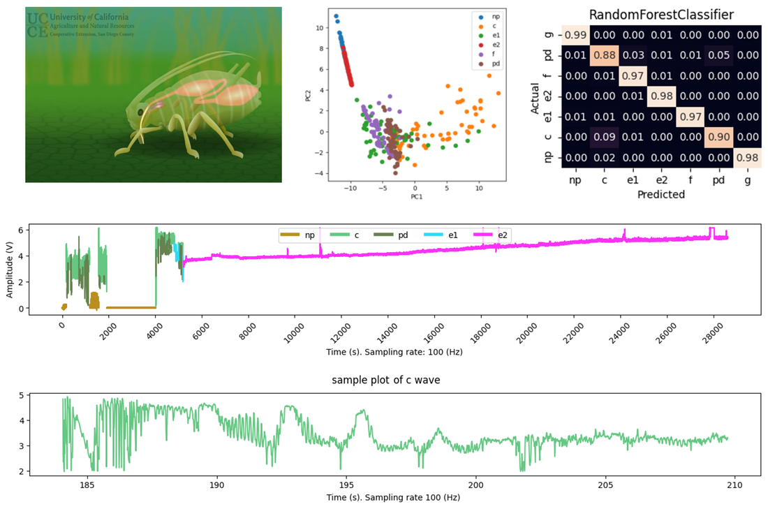
|
The electrical penetration graph (EPG) technique that is used to study the feeding behavior of insects with piercing and sucking mouthparts. In this technique, an aphid and plant are made part of an electrical circuit, and when aphid mouthparts penetrate plant tissue the changes in electrical resistance and voltage are recorded as electrical waveforms. Waveforms are distinct at different feeding stages, reflecting different feeding behaviors including stylet penetration and probing (Pathway phase, PP), non-probing (NP), salivation, and ingestion of cell contents (Sieve element phase, SEP), and xylem ingestion (G). It requires a significant amount of time for a well-trained researcher to annotate the recordings to accurately characterize and interpret these behaviors. A robust and time-saving approach is crucial to yield a higher accuracy of identification and characterization of the feeding behavior. In this project, we aim to detect and characterize behaviors in aphis feeding in wheat with machine learning. We first evaluate the performance of various machine learning algorithms in identifying and characterizing different stages of feeding from waveform signals. A Python package and/or a shiny app will be created for the analysis of electrical penetration graphs to study plant probing behavior of insects.
--- Collaborators: Nalam's Lab at CSU, Université Sorbonne Paris Nord, France, and Indiana State University |
Native and invasive species functional trait variation and drought responses
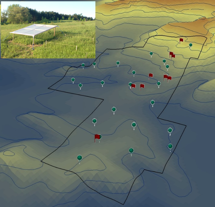
|
This study aims to investigate the impact of drought stress on plant functional traits and how native and invasive species respond to the stress using the integration of airborne hyperspectral and radiative transfer modelling (RTM). We simulated drought stress on grasses using rain-exclusion shelters on different elevation and slopes in with greenhouse plastics that allow light to penetrate while preventing rainwater from entering. Real-time soil sensors were installed in each shelter and the adjacent natural sites, and the soil moisture recorded from these sensors were used in combination with the weather data from an in situ station to evaluate drought conditions. Plant traits were measured at different stages of stress. Leaf and canopy reflectance and airborne hyperspectral imagery were collected to examine the impact of the drought stress on plants across scales. The study provides useful information on vegetation health under drought stress to assist with ecosystem health monitoring, impact assessment, restoration, and conservation.
--- Collaborators: University of Toronto, University of Guelph |
Impacts of soil health and nutrient run-off on crop performance
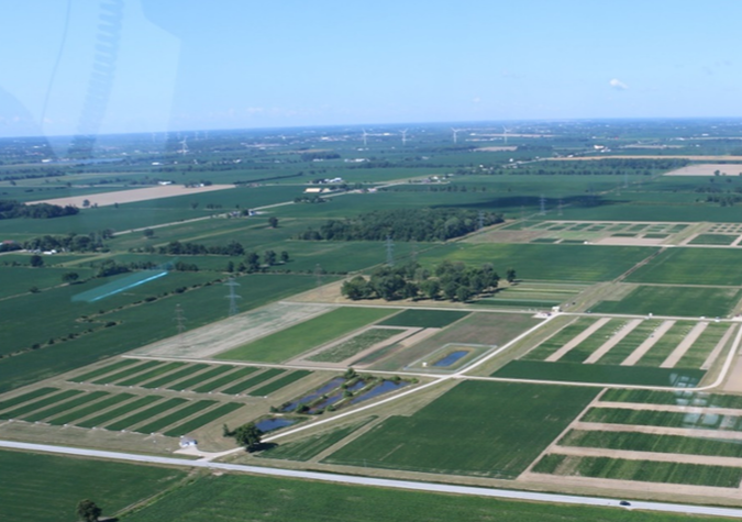
|
This research combines airborne hyperspectral and thermal remote sensing data for studying crop health under various soil treatments including different crop type rotations, nitrogen treatments. The aim of this project is to evaluate the change in photosynthetic performance, biophysical and biochemical properties, and productivity of corn, soybean, and weed under different soil conditions. The study is conducted on an agricultural experiment site, with eleven fields, of Agriculture and Agri-Food Canada in Woodslee, Ontario, Canada in collaboration with Agriculture and Agri-Food Canada, University of Guelph, and University of Windsor.
--- Collaborators: University of Toronto, Agriculture and Agri-food Canada, University of Guelph, University of Windsor |
Machine learning for plant stress detection and characterization
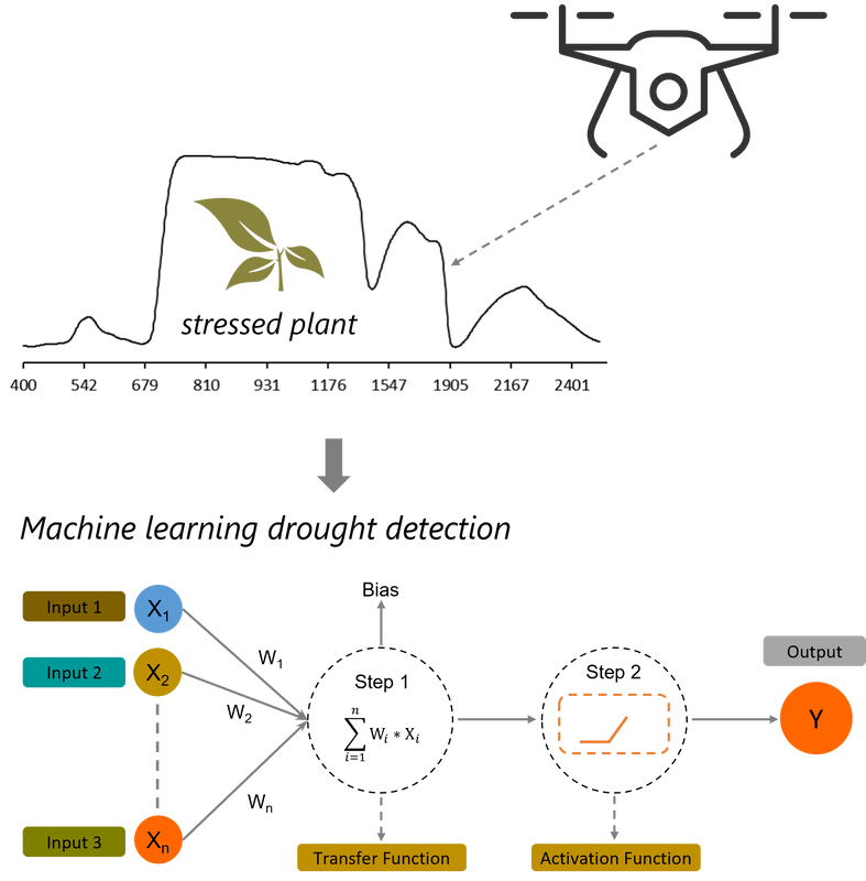
|
Hyperspectral remote sensing which is sensitive to subtle changes in plants is widely used detect early drought and drought evolution over time. Spectral indices are widely used for stress monitoring, given their sensitivity to one or more plant properties. However, appropriate spectral bands are not always apparent for early drought detection and stress progression monitoring since drought response varies by species, from tolerators to competitors. Also, spectral indices typically utilize a few bands and therefore do not exploit information in other spectral regions that are also influenced by drought. With the development of machine learning and increased computational power, the use of full spectra and derivative spectra becomes possible, holding great potential to offer new insights into the drought impacts. In this study, full spectra and derivative spectra were integrated with advanced machine learning algorithms for early drought detection and classification. This study demonstrated the usefulness of integrating deep learning and hyperspectral data in plant stress research for stress impact assessment, recovery, and mitigation.
--- Collaborators: University of Toronto, University of Windsor, Ontario Tech University |
Object-based image analysis (OBIA) for object detection and species mapping
|
Image segmentation is a critical component of the object-based image analysis (OBIA) and interpretation. Improper process in this step may induce in over- or under-segmentation that results in later image classification and interpretation. Typically, the averaged measures of entire-image spatial and spectral properties calculated from all image objects in all bands were often used as the criteria in these studies. However, these overall measures are affected by outliers or extreme values of a small number of objects which drives incorrect conclusion on the assessment and selection of optimal scale for the majority of other objects. This issue becomes more critical with hyperspectral data with a high degree of spectral variability in different spectral bands. In this study, a more thorough evaluation of segmentation parameters using non-outlier measures of segment coefficient of variation and rate of change for a more reliable assessment and selection of optimal parameters for hyperspectral image segmentation. The results demonstrate that by detecting and removing outliers from segmented image statistics, more reliable parameters were determined, and the segmentation result was improved.
--- Collaborators: University of Toronto, Ontario Tech University |
Multi-sensor data fusion for land surface monitoring and disaster mapping
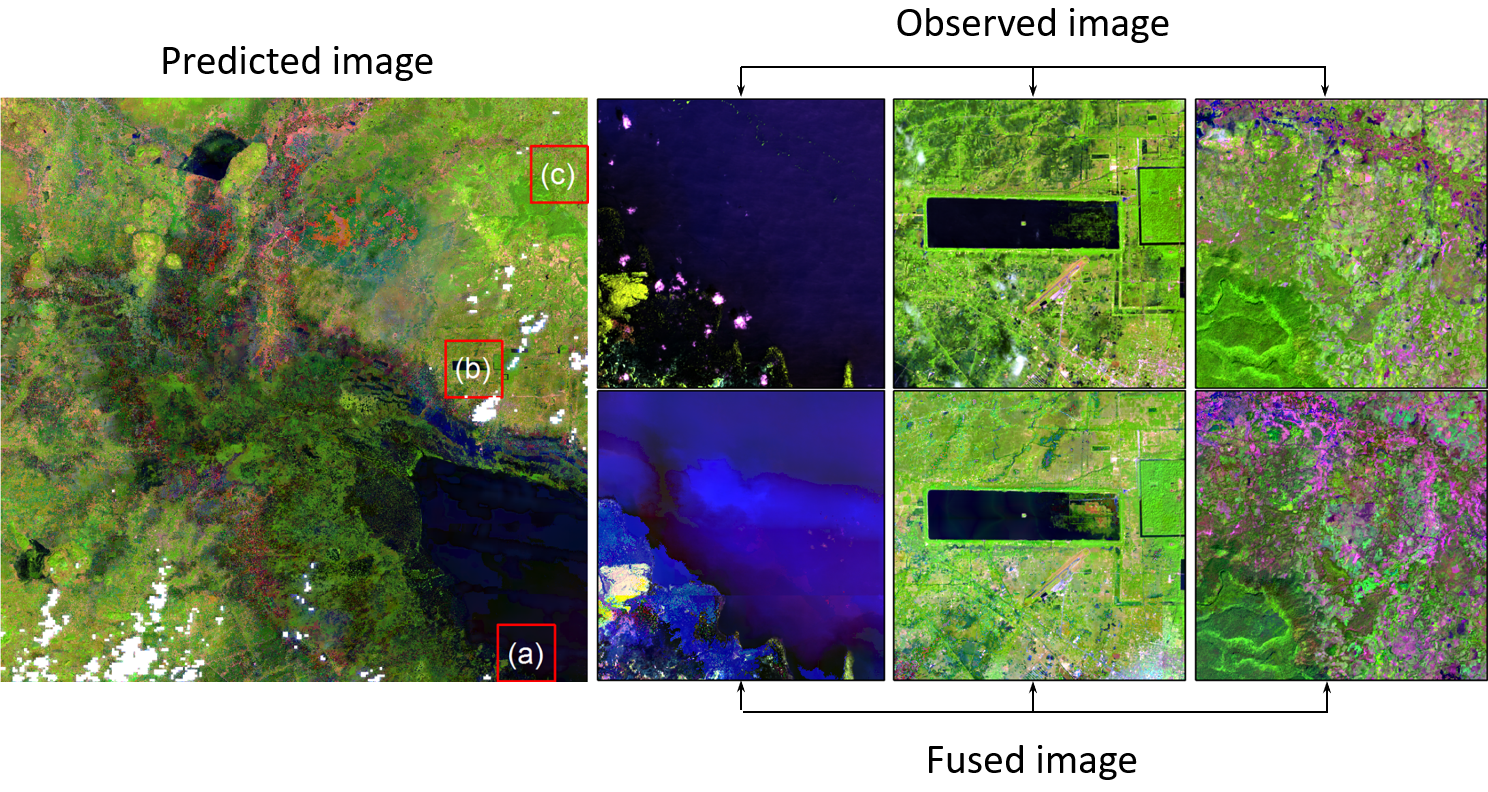
Landsat-MODIS image fusion result. Observed Landsat images (upper row), predicted Landsat-scale images (lower row)
|
Typhoon flooding normally occurs suddenly with short duration, and the thick cloud cover limits the ability of one single satellite to timely capture the inundation extent. Landsat satellite data with a spatial resolution of 30 m is spatially applicable for flooding research; however, its 16-day observation frequency is typically insufficient to observe short-term typhoon inundation. In contrast, despite the coarse spatial resolutions, the Moderate Resolution Imaging Spectroradiometer (MODIS) sensor provide daily data, which is well suited for flood-related investigations. Accordingly, combining these two data set generates a high spatial and temporal image. In this study, the ESTARFM model was used to generate cloud-free synthesized data with 30-m resolution for the delineation of the inundated areas during cloudy days.
--- Collaborators: National Central University, Taiwan |
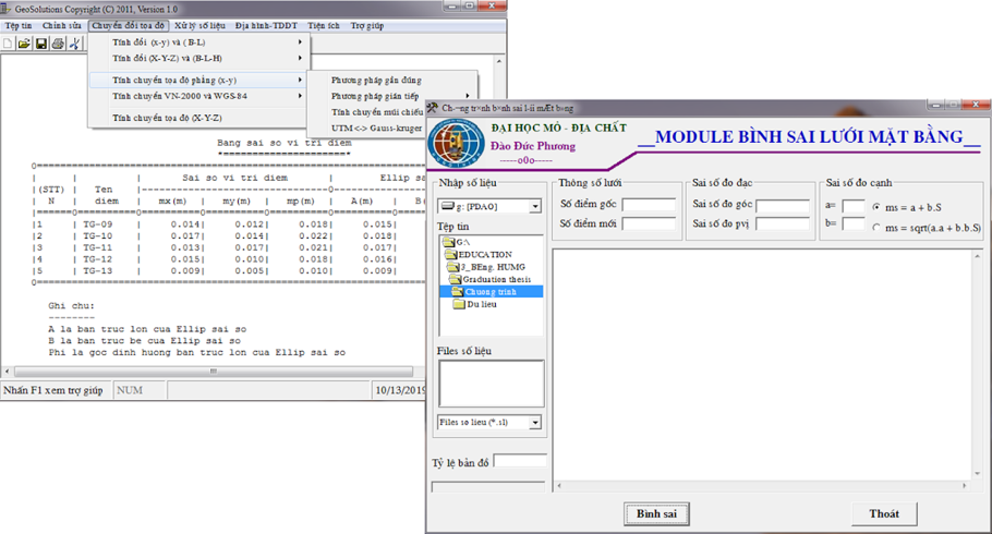
Method and geospatial tool development
|
Coordinate transformation between different coordinate systems is important for national survey network maintenance and management. This study evaluates some widely used approaches of plane coordinate transformation between two coordinate systems. Then, the most suitable formula for Vietnam’s cadastral coordinate network is figured out. An easy- and ready-to-use application software was built by Phuong Dao for surveyors and geodetic researchers. The software has been used not only in practice but also in research and education in the Department of Geodesy, University of Mining and Geology since 2011.
--- Collaborators: Curtin University, Australia |
*** Welcome to the Dao Laboratory's website ***
